


Years ago I compiled a list of favorite streets for walking in Minneapolis and St. Paul, put together on what would today be called “vibes.” These were streets with an ineffable sense of place, corridors I’d fallen for after years of fine-tuning my inner flâneur. The top five list — Selby and Payne in St. Paul, Nicollet, 13th NE and N. First avenues in Minneapolis — seemed right to me but, other than a vague sense of scale, I didn’t really know why.
Fast-forward to 2025, I think I’ve figured out the recipe. Reverse-engineering the historic logic behind my top strolling streets, they seem to all have two things in common. First, they were all streetcar streets, bringing with them the dense mixed-use legacy of turn-of-the-century walkable transportation. That’s key to all the best historic streets, but it’s not the whole story.
The second component is more crucial: All my favorite local streets were somehow sidetracked by urban geography, receiving just the right amount of benign neglect over the years. In each case, these streets became secondary to other automobile commercial corridors, meaning that they had density without the automobile erosion that dominated the later 20th century. In retrospect, that combination is the “secret sauce” for Twin Cities urbanism, and it’s only a shame that more Twin Cities streets can’t offer more of it.
The density factor
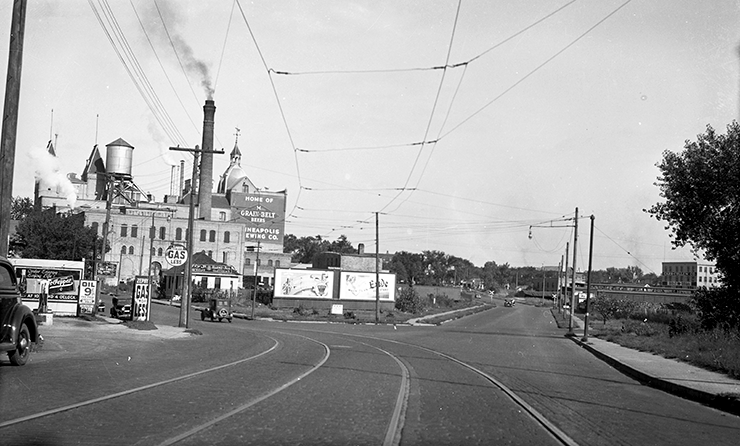
My revelation was triggered by a story on MPR the other day about 13th Avenue NE, an otherwise obscure street in Northeast Minneapolis that has quietly become a go-to stretch for Minneapolis’ hip cuisine. As Gretchen Brown reported last week, restaurants like Minari, Young Joni, and Oro by Nixta have all opened up in an otherwise mundane stretch of Northeast Minneapolis. Really, the latest wave continues an ongoing trend; Back in the day, it was Dangerous Man, 331 Club, NE Social, Theater Latté Da, Rogue Buddha art gallery, and Anchor Fish and Chips that anchored the street’s fascinating scene.
One reason for the concentration is that 13th Avenue NE is one of the smaller Minneapolis streets to boast a streetcar line, one of the last links added to the Minneapolis’ network in 1914. Like other out-of-the-way spots — S. 25th Street in Seward comes to mind — it plopped down a bunch of mixed-use buildings in an otherwise residential and unremarkable part of the street grid, between the riverfront industry and the residential parks to the east.
According to local streetcar expert Aaron Issacs, 13th Avenue gained a streetcar thanks to some engineering details of the Broadway Avenue bridge. It jogged north at the river and ran down 13th for eight blocks to Washington Avenue. When the streetcar disappeared in the 1950s, 13th likewise vanished from the minds of the city’s drivers as Broadway Avenue, two blocks away, received the drive-thrus, strip malls and engineering attention.
That’s the magic formula. The city’s best remaining streets all had historic density, but without the transition to arterial status and the requisite parking lots, narrower sidewalks and car infrastructure that eroded the old built environment.
A St. Paul revival
Payne Avenue provides an example from St. Paul’s East Side. In the early 20th century, this street boasted vibrant commerce built up around the streetcar traffic coming out of downtown. Pressed close to the factory-laden railroads and Swede Hollow, Payne rose up a hill becoming the main street for middle-class Germans and Scandinavians. It was synonymous with upward mobility in those days, but as the streetcar faded from relevance, it was its neighbor a quarter mile to the east, Arcade Street, that became a state highway. Cut off from direct access by a challenging topography, Payne was lucky enough never to have been deemed a major highway arterial.
Today, it features the most contiguous mixed-use facades anywhere in town, over a half-mile from Phalen boulevard up to around Maryland Avenue, with nearly continuous century-old storefronts. Offering a two-lane cross section with bike lanes and parking, Payne is pleasant for strollers while boasting dozens of unique old buildings that are worth examining at length. It’s seeing a renaissance right now, with a broad diversity of shops and entrepreneurs reflecting St. Paul’s East Side diversity.
Nicollet’s ups and downs
Minneapolis’ Nicollet Avenue has an opposite story, a place where folly met felicity thanks to the city government. In this case, they took a historically successful commercial corridor that boasted one of the city’s busiest streetcar lines until the mid-1950s, and tried to “improve” it at the corner of Lake and Nicollet during its urban nadir. The result was the city’s first use of tax-increment financing (TIF) to demolish commercial buildings, leading to an unfortunately timed vacuum of investment. It all culminated in the notorious Lake Street Kmart Building, an inadvertent big box strip mall that disconnected Nicollet Avenue at a key corner, essentially decapitating a key section of Nicollet at 29th Street.
Thankfully that mistake has been undone now, but for a few generations a vibrant stretch of Nicollet became a relative ghost town. My theory is that this amputation led to the birth of “Eat Street,” the branding for a small commercial stretch along Nicollet, and the preservation of so many historic mixed-use buildings. As an out-of the way stretch of a key street, this portion of Nicollet remained walkable and calm, with fewer parking lots and strip development than many of its neighbors.
It also meant that this stretch of Nicollet never received “improvement” by city or county engineers, who regularly bulldozed buildings or narrowed sidewalks to add turn lanes and the like. Likewise, Nicollet was never connected to the I-94 freeway system, keeping traffic much lower than nearby Lyndale or Hennepin avenues.
St. Paul’s Selby rebound
N. First Avenue in downtown Minneapolis is probably the most neglected street from a traffic point of view. Somehow it dodged both the one-way-street trend and Gateway District demolition that subsumed most downtown thoroughfares, keeping it calm and walkable all these years. Given its pedestrian orientation, it’s not a coincidence that it has more street life than the rest of downtown put together.
Finally, St. Paul’s Selby Avenue is one of the city’s narrowest commercial streets, once home to a critical streetcar line. It never became a main arterial road like nearby Marshall Avenue. That’s probably why it remains the most walkable stretch in the area, better than nearby Grand Avenue, a wider street that encourages speeding. By contrast, Selby’s narrow cross-section keeps traffic calm and more pleasant for strollers, easier to cross the street between shops.

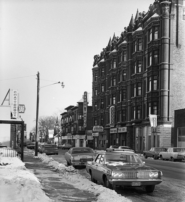
Selby had its own dramatic history over the years, a ground zero for riots and unrest in the 1960s that led to disinvestment and eventual rebound, thanks to historic preservation, the Rondo community and other neighborhood investment.
That’s the story with a lot of these streets. In each case, the key ingredients were a mix of historic streetcars, historic resources, neglect and love. Today, though, these are some of the most interesting and walkable places to find yourself in the Twin Cities. Next time you’re out and about, stop and admire the geometry of these unique streets.


Bill Lindeke
Bill Lindeke is a lecturer in Urban Studies at the University of Minnesota’s Department of Geography, Environment and Society. He is the author of multiple books on Twin Cities culture and history, most recently St. Paul: an Urban Biography. Follow Bill on Twitter: @BillLindeke.