The New Year will likely get off to a snowy start in the Kansas City area as two weather disturbances are likely to pass through the region early in 2025, according to the National Weather Service.
Colder weather is already moving into the metro. The weather service said any lingering rain will end Tuesday morning. Still, temperatures will only reach the upper 30s, a significant change from Monday, when the temperature climbed to 46 degrees. Typically, Kansas City sees temperatures around 39 degrees this time of year.
Winds with gusts around 30 mph will make it feel much colder. Wind chill temperatures are expected to be in the mid-20s for most of the day.
According to the weather service, those heading out on New Year’s Eve to celebrate should dress warmly. Temperatures are expected to fall into the mid-20s, and wind chills will be in the teens.
New Year’s Day will be sunny, with temperatures climbing to 39 degrees.
Two chances of snow in Kansas City area
The first snow of the New Year could arrive on Thursday, although areas north of the metro have a greater chance of seeing the light snow.
Minor snow accumulations are expected along and north of U.S. 36 highway across northern Missouri, the weather service said. The metro has a low chance, around 30%, of seeing a trace or more of snow. The heaviest snow accumulations are expected across Iowa.
The snow could impact travel for those in northern Missouri.
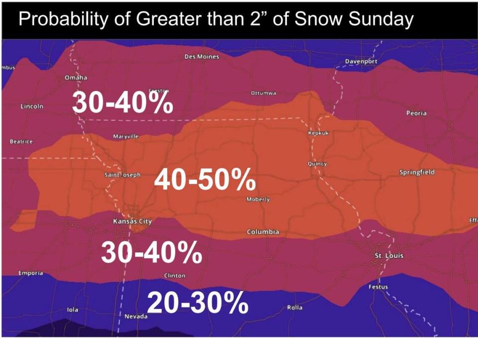
A bigger, more significant storm system is expected to impact the region Saturday night into Sunday, the weather service said.
“Snow is expected to prevail across the northern half of Missouri, while farther south precipitation may be a wintry mix,” the weather service said. “If you have travel plans this weekend, stay tuned to the latest developments in this impactful storm system.”
The weather service said the forecast remains uncertain about the storm’s track and expected snowfall amounts. Parts of the Kansas City metro area are included in an area with a 40% to 50% chance of more than 2 inches of snow falling on Sunday.
“Given all these unknowns, we cannot make any call for snowfall amounts at this time,” the weather service said.
Temperatures are expected to dive, falling to the upper 20s on Saturday and Sunday and around 20 on Monday.
Below-average temperatures and precipitation are expected next week.
A more significant storm system is expected to impact the Kansas City region Saturday night into Sunday, the National Weather Service said. Snow is expected across the northern half of Missouri, while areas farther south could see a wintry mix. There’s uncertainty in the forecast, so those traveling this weekend will want to stay tuned to the latest developments.